
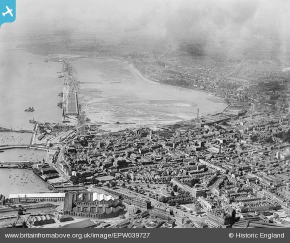
EPW039727 ENGLAND (1932). Reclamation of the Western Docks between Royal Pier and Millbrook Point, Southampton, from the south-east, 1932
© Copyright OpenStreetMap contributors and licensed by the OpenStreetMap Foundation. 2026. Cartography is licensed as CC BY-SA.
Nearby Images (4)
EPW039727

 0°
0m
0°
0m
EPW042962
 237°
172m
237°
172m
EPW041064
 163°
231m
163°
231m
EPW042958
 102°
249m
102°
249m
Details
| Title | [EPW039727] Reclamation of the Western Docks between Royal Pier and Millbrook Point, Southampton, from the south-east, 1932 |
| Reference | EPW039727 |
| Date | August-1932 |
| Link | |
| Place name | SOUTHAMPTON |
| Parish | |
| District | |
| Country | ENGLAND |
| Easting / Northing | 442090, 111150 |
| Longitude / Latitude | -1.4014226547376, 50.897739583889 |
| National Grid Reference | SU421112 |
Pins
 Christ Church Freemantle Christ Church Freemantle |

Liz coe |
Thursday 26th of October 2017 12:40:35 PM |
| This area looks like a concrete works with components for either the quay side or warehouses waiting to be moved to location along the new quay. It can be seen in more detail in EPW032341. |
Maurice |
Saturday 19th of January 2013 08:23:52 AM |
|
Work on the site of the King George V Graving Dock (Dry Dock) which at 1,000ft long by 135ft wide and 45ft deep could take the largest ships afloat, although the 'Queen Mary' was going to be a tight squeeze. This dock replaced the float dry dock as seen in EPW032342. |
Maurice |
Thursday 27th of December 2012 09:59:28 AM |
| This area has now been further developed as the Southampton Container Port (1970s to present, taking inland development of Southampton Docks as far as it can go. Future development will be on the opposite side of the river. |
Maurice |
Thursday 27th of December 2012 09:56:26 AM |
| On this section at the western end of the new dock there appears to be a cofferdam in place to allow the construction of the new wall on pile driven into the sea bed. Once the wall is completed and water tight the quay immediately behind can be consolidated and the area further back drained of the remaining water. |
Maurice |
Thursday 27th of December 2012 09:36:07 AM |
| In this middle section we see the progression of work towards a finished wall and dock surface. There is much construction equipment both on the new quay and in the water. |
Maurice |
Thursday 27th of December 2012 09:32:52 AM |
| The new dock was built from the eastern end. Here we see an early section with tugs and barges against the new wall, with the first of the transhipment sheds almost completed.
|
Maurice |
Thursday 27th of December 2012 09:30:53 AM |
| What appears to be two dredgers with a large tug in between and another, small tug on the out side. |
Maurice |
Thursday 27th of December 2012 09:26:41 AM |
| The reclamation of the land behind the new Western Docks in Southampton was one of the largest non-rural reclamation schemes ever carried out in Britain. Unlike the reclamation of agricultural land from the sea in the Fens, the Somerset Level and around the Dee Estuary and Morecombe Bay in the north west of England, this land was intended for immediate industrial use. The ground level was made up with mud and silt dredged from the sea bed outside the new dock wall and chalk brought by rail from a pit beside the the main Southampton to London railway line at Micheldever, about 16 miles to the north. |
Maurice |
Thursday 27th of December 2012 09:24:15 AM |